Project Overview
Natural disaster prediction and management requires an ability to i) reliably predict risk of occurrence and ii) monitor in real-time the actual situation on the ground, so that emergency services, government agencies and the community at large can be well informed and able to take appropriate timely evasive action to minimise loss of life and property. Of particular relevance is the need to have reliable real-time high spatial resolution information on i) soil moisture content of areas at risk of flood or landslide, ii) fuel and soil moisture content of areas at risk of bushfire,
iii) location of flood water inundation along with its spread, and iv) location of fire fronts along with their speed and direction of travel. Soil moisture information is also essential to providing information on drought severity and extent to support relief claims and to predict likely flow-on effects in terms of food availability. A fundamental challenge is that current satellite technology, while useful, is not able to meet the operational demands for providing such information. In brief, optical data is unable to see through clouds and smoke and does not provide information on soil moisture content; synthetic aperture radar (SAR) data has a long repeat interval, is difficult to interpret, and requires long processing times; altimetry data has limited coverage, spatial resolution and repeat interval and is only applicable to measuring water inundation; and passive microwave radiometry, while applicable to most of the required applications, suffers from having a coarse resolution at satellite orbit heights. Consequently, this project will develop and demonstrate a new state-of-the-art near-space concept for natural disaster prediction and management using round-the-clock passive microwave observation capabilities at L- and Ka-band (1.41 GHz and 36.5 GHz), with a spatial resolution two orders of magnitude better than currently available from satellites, by leveraging the emerging loiter capability in platforms that can operate at the edge of space for months at a time.
While passive microwave technology is clearly well suited to meeting many of the fire and flood requirements, the current limitations are that i) the available data from satellites is spatially too coarse, and so ii) the current data processing and retrieval algorithm capabilities do not meet the needs of these applications. The spatial resolution of passive microwave measurements improves with decreased altitude of the platform; resolution is also inversely proportional to the antenna size. Thus, to achieve the required few hundred meters at L-band wavelengths, it is necessary to have either a 600m diameter antenna at spacecraft altitudes, which is not practical, or fly a much smaller antenna closer to Earth. Accordingly, near-space (20km altitude) is the optimal location for natural disaster surveillance with a manageable antenna size (20m). Fortuitously, several companies are now testing and/or offering what are called high altitude platforms (HAPs) for a range of applications, such as telecommunications and Earth observation, though none are offering the unique sensing capabilities discussed here. These HAPs can be tasked to areas of interest to provide essential information for natural disaster prediction, and/or loiter there to provide real-time information on the natural disaster event as it unfolds. Therefore, this project seeks to undertake a complete end-to-end baseline operational mission design, including algorithm theoretical basis, for the first ever near-space observation, monitoring and prediction capability of natural disasters such as fires, floods and landslides using passive microwave observations. Consequently, this project will advance the science necessary to realise a near-space Earth observation capability, allowing around-the-clock monitoring of fire, flood and landslide susceptibility, initiation and spread, using passive microwave technology in an operational context at an unprecedented spatial resolution. Importantly, it represents Australia’s commitment to Earth observation and a realisation that we cannot wait for others to determine the future of such an important observing capability for us.
This ambitious study will therefore undertake the following project objectives:
-
Determine the optimal design for a L- and Ka-band patch array passive microwave radiometer instrument that can be carried by a long endurance high altitude uninhabited platform within its size, weight and power envelope;
-
Develop and demonstrate an algorithm for estimating fire fuel water and soil moisture content at high spatial resolution under a range of environmental conditions (grasslands, savannah, and sclerophyll forests);
-
Develop and demonstrate an algorithm for monitoring of inundation at high spatial resolution in complex urban and natural environments with the rate and direction of expansion;
-
Develop and demonstrate an algorithm for monitoring of fire front locations at high spatial resolution with information on the speed and direction of travel; and
-
Develop and demonstrate a landslide risk prediction capability using high resolution soil moisture information.
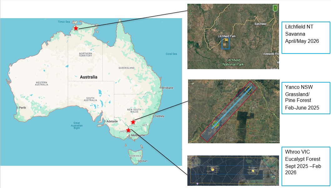
Locations of the NEST experiments
Schedule of NEST experiments
Created: July 2025 Last Modified: February 2026
Maintainer: Xiaoling Wu,xiaoling.wu@monash.edu; Jeff Walker, jeff.walker@monash.edu